
Moderate to heavy accumulations of snow, sleet, or ice are expected Friday night through Saturday night.
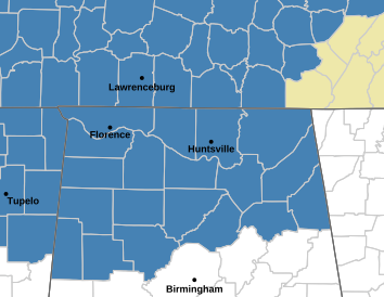
...WINTER STORM WATCH IN EFFECT FROM FRIDAY EVENING THROUGH SUNDAY
AFTERNOON...

* WHAT...Moderate to heavy accumulations of snow, sleet, or ice are
  expected Friday night through Saturday night. Snow and sleet
  accumulations of at least 2 to 3 inches. Ice accumulations above
  one quarter of an inch. Locally higher amounts possible.

* WHERE...Portions of north central, northeast, and northwest
  Alabama and southern middle Tennessee.

* WHEN...From Friday evening through Sunday afternoon.

* IMPACTS...Expect power outages and tree damage due to ice
  accumulations. Travel could be impossible.

PRECAUTIONARY/PREPAREDNESS ACTIONS...

Persons should consider delaying all travel. If travel is absolutely
necessary, drive with extreme caution. Consider taking a winter
storm kit along with you, including such items as tire chains,
booster cables, flashlight, shovel, blankets and extra clothing.
Also take water, a first aid kit, and anything else that would help
you survive in case you become stranded.
 Scammers Relentless Across Our Area
 Crime Stoppers Tip Aids In Finding Missing Child
 Lincoln County Sheriff's Spring Citizens Academy Underway
 Harvest Man Arrested on Fraud and Identity Theft Charges